


Penig subcamp
| Place: | Langenleuba-Oberhain (Penig, Central Saxony) |
|---|---|
| Type: | Sites of National Socialism |
| Dating: | Second World War | 1944 - 1945 AD. |
Description
In the summer of 1944, armaments production in National Socialist Germany reached an all-time high. Without the use of forced laborers, these enormous increases would never have been possible. From June 1944, more and more concentration camp prisoners were used for forced labor in Saxony as well. The newly established companies include.a. the Langenleuba-Oberhain camp, where from January to April 1945 around 700 Jewish women from Hungary were forced to work in the production of aircraft parts under devastating conditions at the Max Gehrt factory in Penig.
Michael StrobelLink https://www.erinnerungsort-penig.de/entstehung-des-lagers/
History of the Max Gehrt plant in Penig
The Max Gehrt plant in Penig emerged from a branch of the Magdeburg "Gesellschaft für Papierhohlkörper und Maschinenanlagen" founded in 1915. The most important products of the "Papyroplastwerke Penig" included "paper hollow bodies" and special machines. The company developed into an important supplier to the cardboard and paper industry. The growth is also reflected in the construction of new production halls during the 1930s. In 1936, the entrepreneur Max Gehrt (1863-1941), who had previously operated a "raw production trade" in rags and paper in Glauchau, and later also scrap, non-ferrous metal and iron girders, acquired the property and factory. It is unclear under what circumstances the Penig plant was converted into an armaments factory in 1944, producing aircraft parts for Junkers Flugzeug- und Motorenwerke AG Dessau. The company in Glauchau still exists today as a recycling and waste disposal company.
Michael StrobelImage Source ©erinnerungsort-penig.de/max-gehrt-werk/Abb. 2.
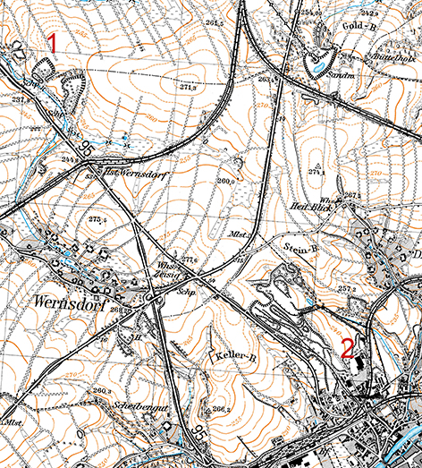
The relationship between the storage location (1) and the factory premises (2)
The course of the war also led to an acute labor shortage at the Max Gehrt factory in 1944, which was initially to be compensated for by around 450 Soviet forced laborers. The company management planned a barracks camp to accommodate them. Why an abandoned gravel pit about three kilometers away from the plant (2) in the north of Penig was chosen for this purpose is most likely due to the easy availability of the land. The extraction of fluviglacial gravels and sands here dates back well into the 19th century. To the north-east of the former Reichstrasse 95, three pits were already in operation around 1900, digging deep into the steep slopes of the Erlsbach. The barracks camp was finally built in the middle one (1).
Michael StrobelImage Source Kartengrundlage ©GeoSN 2024.
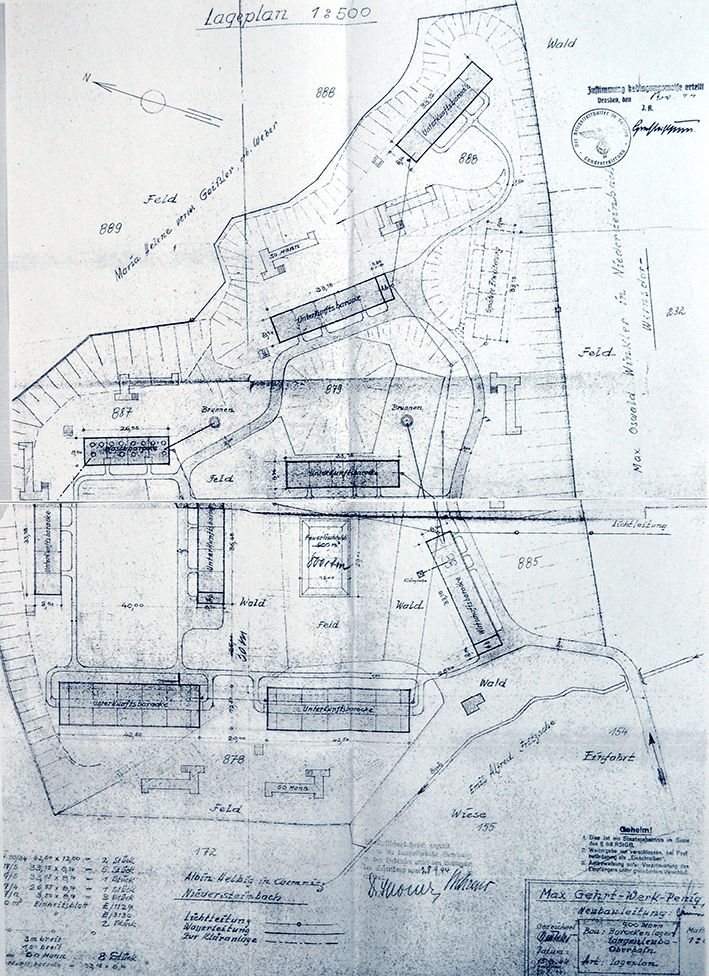
Storage plan
The plans from 15.8.1944 included 7 accommodation barracks as well as a washing and utility barrack, the distribution of which within the gravel pit referred to embankments and spoil heaps and did not extend beyond the former boundaries in order to avoid additional land acquisition. An extinguishing water basin and presumably a roll call area were to be built on generously dimensioned open spaces. Latrines for "50 men" were allocated to the accommodation, a well for the water supply to the service and washing barracks and a septic tank to the kitchen wing. However, it appears that a fence was originally planned, but no watchtowers.
Michael StrobelImage Source ©erinnerungsort-penig.de/entstehung-des-lagers/Abb. 1.
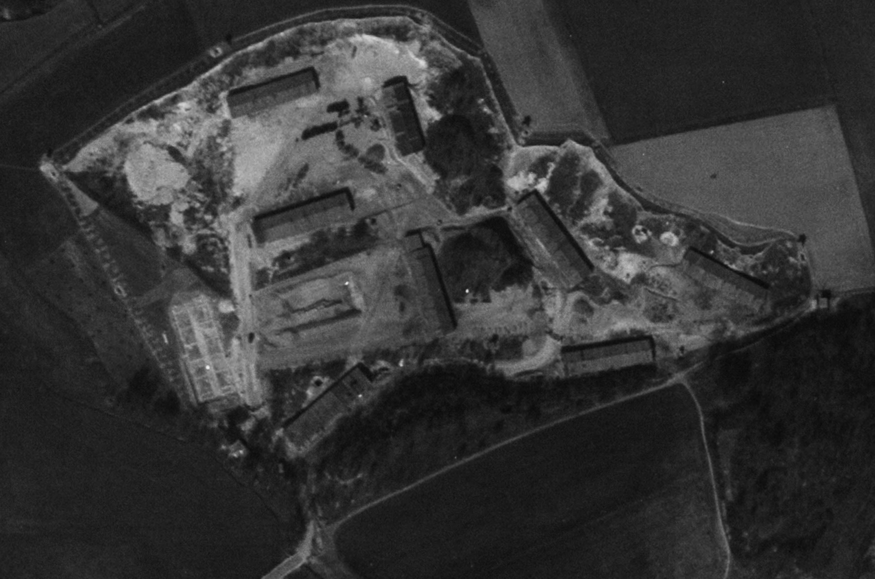
Allied aerial photograph from April 10, 1945
As the plan was obviously not approved until November 1944, subject to conditions, it is unlikely that construction began early. In addition, there are certainly discrepancies between planning and execution, as an Allied aerial photograph from April 10, 1945 shows: While the construction of the extinguishing water basin does not appear to have progressed beyond the excavation stage, one of the two large accommodation barracks in the west was not built at all and at most the strip foundation of the other was laid. Instead, a barrack was erected in the SE, which is only shown on the plan as a "later extension". The barbed and electric wire fencing, the guard's path and several watchtowers to the north and east are also clearly visible.
Michael StrobelImage Source ©erinnerungsort-penig.de/entstehung-des-lagers/Abb. 2.
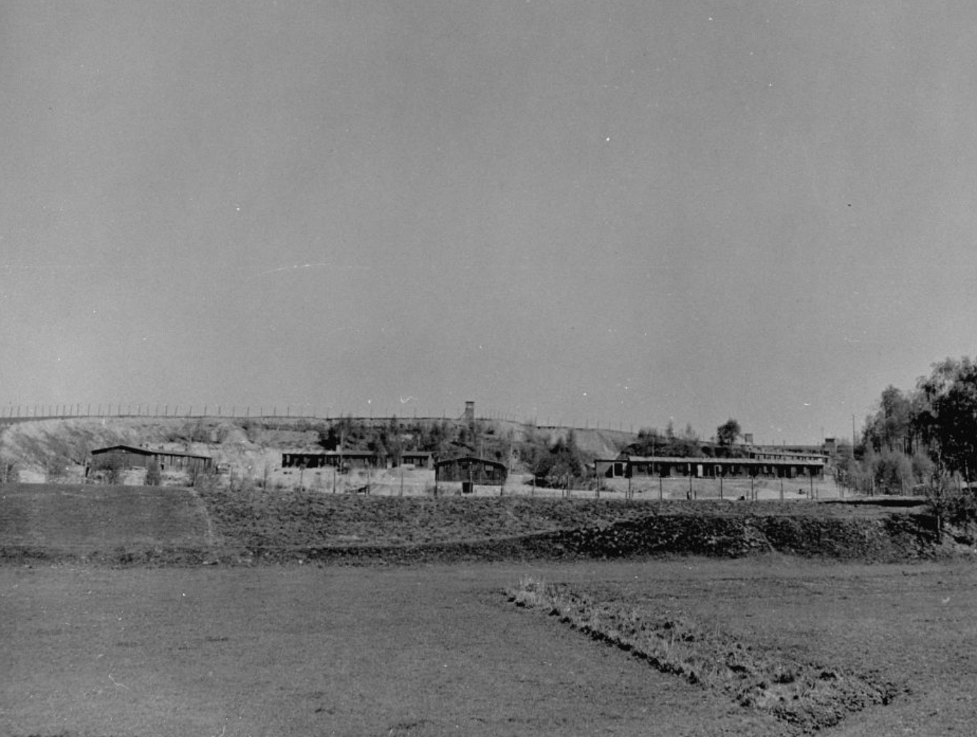
Photo from 11.4.1945
Just one day after the US aerial survey, on 11.4.1945, two days before the dissolution and four days before the liberation by American soldiers, an unknown photographer documented the camp grounds and thus the view, presumably from the then Reichstraße 95, of the central barracks grouped around the open spaces in the center of the gravel pit. The photograph also reveals where watchtowers stood and where the camp fence ran, making it an important addition to the Allied aerial photographs. Two further watchtowers on the north side and in the NW corner are not visible on the print. Hidden behind the group of trees on the right of the picture are the economic wing and two accommodation barracks, which were already in a slightly elevated position in the SE corner of the gravel pit. Between the trees, the outline of a shed or shelter in the entrance area of the camp, which is already marked on the site plan, can also be seen.
Michael StrobelImage Source N.N., Foto 026-15.001 ©Fotoarchiv Gedenkstätte Buchenwald.
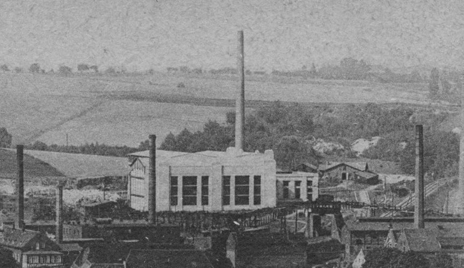
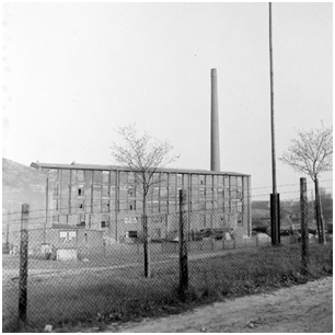
The factory building in April 1944
Initially, the camp appears to have housed Soviet forced laborers who were transferred to Penig and Herrnsdorf near Wolkenburg in late December 1944 or early 1945. On January 12 or 13, 1945, around 700 female concentration camp prisoners from the Ravensbrück concentration camp arrived in open cattle wagons directly at the factory site, which was connected to the rail network. The Jewish women had been arrested in Budapest in November and December under the fascist collaborationist government (Szálasi regime, "Arrow Crossers") and deported to Ravensbrück. From January to April, the completely exhausted women had to work three eight-hour shifts every day and walk a total of six kilometers between the camp and the factory grounds. Catastrophic hygienic conditions and malnutrition claimed at least 14 lives, who were buried on the camp grounds. Around 115 people were crammed into each barrack.
Michael StrobelImage Source ©erinnerungsort-penig.de/max-gehrt-werk/Abb. 3.
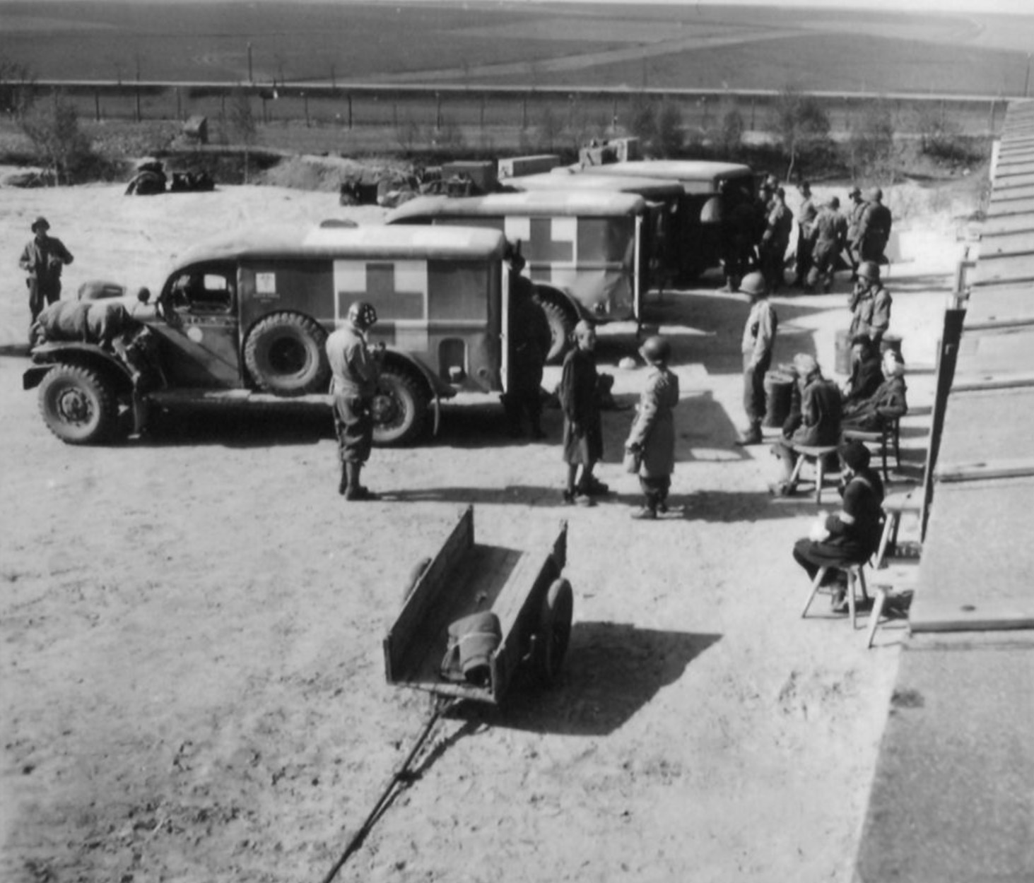
Ambulances parked in front of the northern accommodation barracks
On April 13, 1945, the SS guard team, which consisted of "ethnic German" SS members and female guards, dissolved the camp and drove the prisoners on a death march towards Chemnitz and Mittweida. Almost 80 sick and severely weakened prisoners remained in the barracks and were liberated and cared for by American soldiers on April 15. The guards were never brought to justice.
Michael StrobelImage Source D. E. Scherman, Foto Nr. 245.046 ©Fotoarchiv Gedenkstätte Buchenwald.
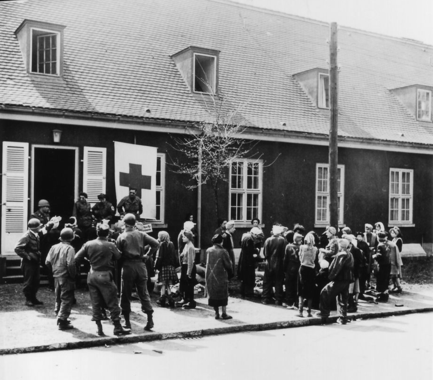
In front of the former air force hospital
Members of the 76th Medical Battalion of the 6th US Armored Division took over the transport to the air force hospital at Altenburg airfield, where the women received medical treatment. Several died as a result of the forced labor. The survivors were often only able to return home after weeks or months.
Michael StrobelImage Source D. E. Scherman, Foto Nr. 245.067 ©Fotoarchiv Gedenkstätte Buchenwald.
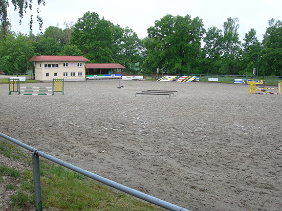
View across the riding arena to the southwest
Even though the gravel pit area is now used as a riding arena and has been remodeled, the remains of barracks can still be expected, especially in the raised edge areas to the east. There are also likely to be traces of the fencing above the gravel pit embankment and of the watchtowers. The subcamp has been listed as an archaeological monument since September 2018.
Michael StrobelImage Source M. Strobel, Foto ©LfA 2020.
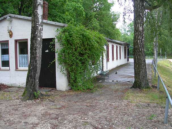
Club building in the area of the former wash hut
Apart from the strip foundations of the barracks that were never erected, an aerial photograph from the 1950s shows nothing that would indicate the camp. Obviously, all the barracks had been dismantled by then and traces had been removed. The wash hut once stood exactly where the clubhouse is now located on a slight terrace. At present, however, everything speaks against continuity.
Michael StrobelImage Source M. Strobel, Foto ©LfA 2020.
Former access area with memorial stone and information board
A memorial stone in the former entrance area commemorates the camp; a notice board next to it provides information about its history. In addition, the websites "erinnerungsort-penig.de" of the citizens' initiative "Gesicht Zeigen" and "gedenkplaetze.info" of the Pirna association AKuBiZ e.V. offer comprehensive further material (see literature).
Michael StrobelImage Source M. Strobel, Foto ©LfA 2020.
Literature
Hans Brenner/Wolfgang Heidrich/Klaus-Dieter Müller/Dietmar Wendler (Hrsg.), NS-Terror und Verfolgung in Sachsen (Dresden 2018).
Bürger_inneninitiative Gesicht zeigen - Netzwerk für Demokratisches Handeln, Erinnerungsort Penig. https://erinnerungsort-penig.de/max-gehrt-werk/
https://erinnerungsort-penig.de/entstehung-des-lagers/
Gedenkplätze. https://www.gedenkplaetze.info/konzentrationslager/konzentrationslager-buchenwald-aussenlager-penig
https://fotoarchiv.buchenwald.de/ (Penig)
Note on monument protection
Archaeological monuments are protected by the Saxon Monument Protection Act. A permit under monument law is required for ground interventions or construction measures.
Permalink
https://archaeo-sn.de/en/ort/penig-subcamp/
Citation
Michael Strobel, Penig subcamp. In: Landesamt für Archäologie Sachsen, Website archaeo | SN (22.10.2024). https://archaeo-sn.de/en/ort/penig-subcamp/ (Stand: 29.09.2026)
