

Early medieval castle complex at Hof-Stauchitz
| Place: | Hof (Naundorf, North Saxony) |
|---|---|
| Type: | Fortified system |
| Dating: | Early Middle Ages | 800 -1000 AD. |
Description
On a gravel ridge jutting out into the former Jahna floodplain near Hof-Stauchitz are the remains of a deeply staggered, early medieval fortification consisting of up to three ditches and a ring wall. Several phases of expansion and renovation indicate that the castle was of particular importance in its time. However, whether the monument is, as some experts assume, the "urbs quae dicitur Gana“ has not yet been proven with certainty. According to historical tradition, Gana was the main castle of the Daleminzians, which was destroyed in the winter of 928/929 AD. Chr. by King Henry I. has been destroyed. An exploratory excavation in 2003 also revealed features and pits from various prehistoric periods. Today, the archaeological monument is under acute threat of destruction due to the ongoing arable use of the site.
Annemarie ReckDiscovery of the site
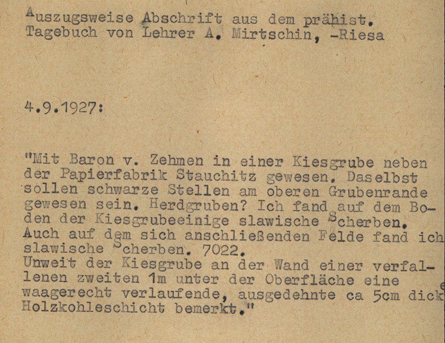
The search for the exact location of the historically significant "Gana" has occupied experts and history buffs for almost 250 years. Many have focused their attention primarily on the etymologically related Jahna. During his research in the 1920s and 1930s, however, the Riesa teacher and well-known local historian Alfred Mirtschin became aware of an area on the border between the villages of Hof and Stauchitz, where a paper mill was located at the time. On the Saxon mileage sheet, the name "der Burgberg" was noted on a map section for this area. During prospections in the surrounding fields, he had already come across promising Slavic finds. Further finds came to light in two places that were used as gravel pits. On the southern edge of the castle hill, about 1 m below the surface, he came across a charcoal layer and further Slavic pottery, as well as plenty of animal bones from pigs and horses.
Annemarie ReckImage Source OA 66290, 55, Auszug Tagebuch A. Mirtschin ©LfA 1966.
First scientific inspections
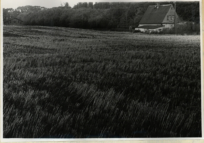
In the decades following the war, research was given new impetus by the efforts of Werner Coblenz, who was director of the State Museum of Prehistory in Dresden from 1949. Although he also supported the thesis that Gana was probably to be found near Hof-Stauchitz, there was still no conclusive evidence. In 1966/1967, the Dresden State Museum of Prehistory carried out the first detailed inspection of the site and drew up a contour plan. This was followed in 1970/1971 by a precise topographical survey of the ground monument.
Annemarie ReckImage Source H. Quietzsch, Foto ©LfA 1971.
Exploring the castle complex
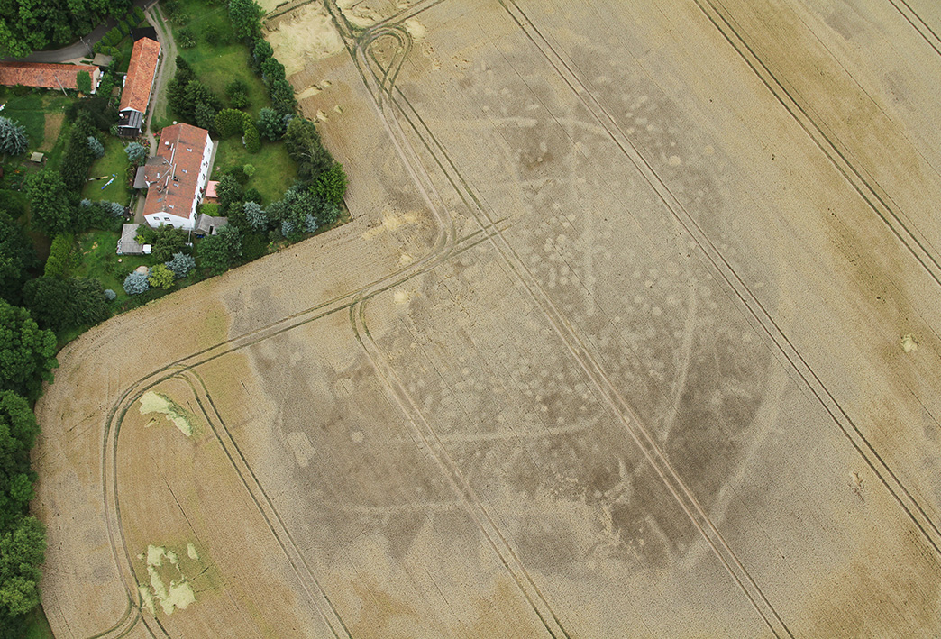
Even the first aerial photograph of the site, taken by Otto Braasch in 1992, was astonishing in its richness of detail. Due to the gravelly subsoil and a covering of poor quality soil, small-scale soil differences in plant growth are already apparent. Regardless of the type of crop growing on the field, features and even individual construction details of the defensive wall can therefore be read as vegetation characteristics. Geophysical measurements from 2003 by Krzysztof Misiewicz from the Catholic University of Warsaw and an initial exploratory excavation in 2003 through the rampart and a second control excavation in 2013 confirm the structure of the castle complex.
Annemarie ReckImage Source M. Rummer, Foto ©LfA 2003.
Geophysical prospection
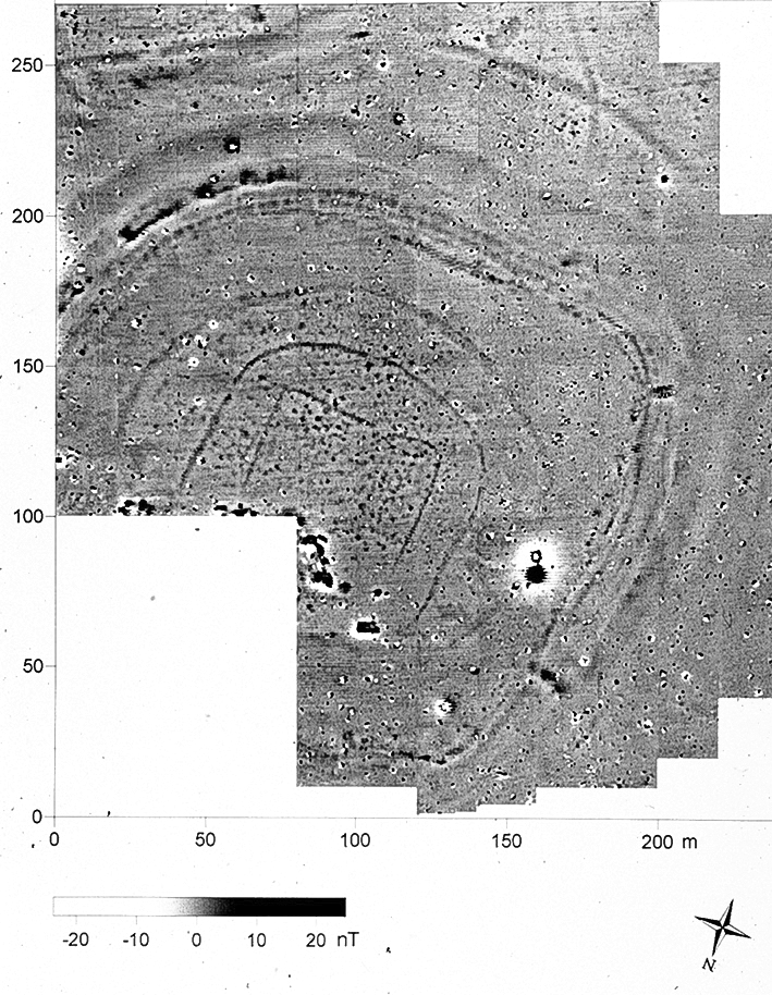
The geophysical survey in March 2003 was intended to provide information about the expected structures and help with the layout of the planned excavation section. The investigations carried out by the Catholic University of Warsaw revealed a deeply staggered defense system, which had already been indicated in the aerial photographs. Behind a narrower ditch in front was a deeper ditch, which was probably originally filled with water. Behind it was a massive rampart with a palisade on top. A boxwork was built into the rampart for stabilization, which is also visible in the magnetogram. Another roundish ditch surrounded a narrower, oval ditch and an almost square one. The latter could possibly originate from palisades. The inner enclosure covers an area of 75 x 75 m. Numerous pits, especially within the rampart, indicate lively settlement activity. A total area of 5.5 ha was surveyed.
Annemarie ReckImage Source K. Misiewicz, Magnetogramm ©LfA/Katholische Universität Warschau.
The construction phases
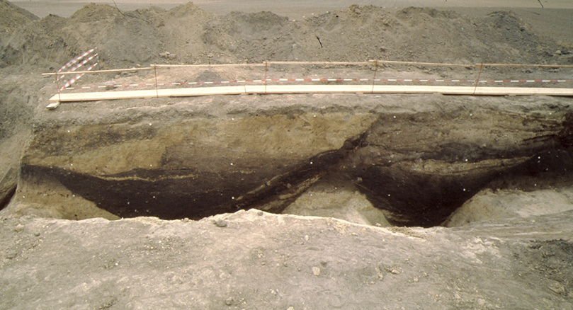
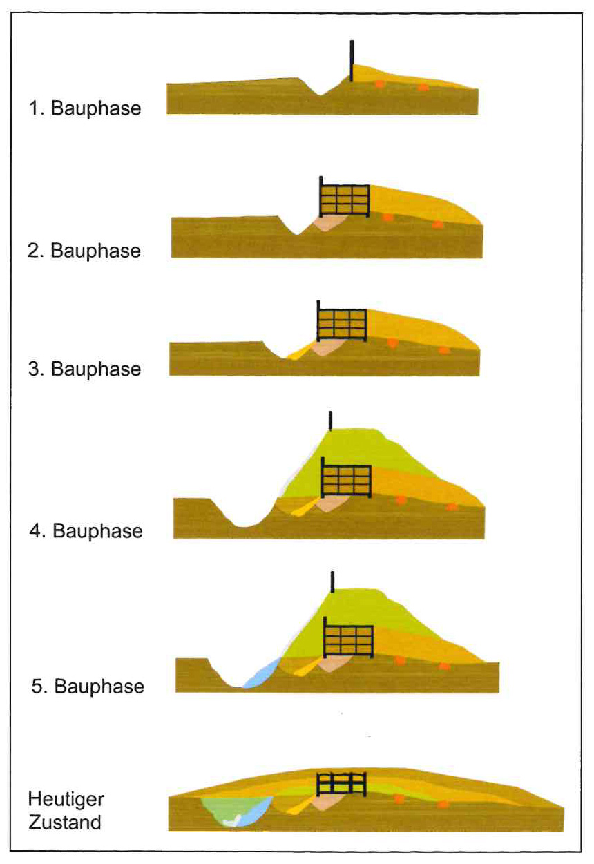
Excavations in 2003 and 2013 also revealed several expansion phases of the castle complex. Its fortifications consisted of at least three ditches in the interior and a ring wall, which can still be seen today as a flat bump in the terrain. Its elevation conceals a box structure filled with earth. Numerous charred wooden beams were still visible in the profile of the excavation cuts. They indicated that the defensive wall had been destroyed by fire and had been renewed at least once together with the ditch in front of it. In a further construction phase, the rampart was reinforced with sand and gravel. The material for this came from a 5 m deep and up to 12 m wide ditch, which was probably fed with water from the marshy lowlands in the Jahna floodplain. In an earlier expansion phase, the ditch was only half this size.
Annemarie ReckImage Source M. Rummer u.a. 2014, S. 26., Abb. 5.
Findings from other periods
The interior of the site on the central gravel knoll covers an area of approx. 2.6 ha and is littered with building structures. However, the selective re-excavations by A. Mirtschin and the excavations in 2003 showed that the flood-free area had been repeatedly visited since the Neolithic period. Among other things, a late Neolithic stool burial (around 2800 BC) came to light in the sondage section. Other finds indicate a settlement during the Late Bronze and Iron Ages (1000-600 BC) and the Migration Period (400-600 AD). It cannot therefore be ruled out that the majority of the findings date from other periods of prehistory and early history.
Annemarie ReckImage Source R. Heynowski, Foto ©LfA 2014.
Endangered ground monument
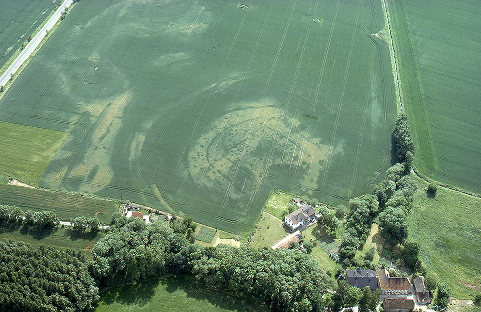
The arable use of the site since the 19th century poses an acute threat to the preservation of the archaeological monument. Around 1900, the rampart must have been 1 m higher in the terrain. A comparison between various digital terrain models (DTMs) from 2008 and 2020 showed that material up to 10 cm high had been removed in the meantime and shifted into the depressions. Progressive soil cultivation with heavy agricultural equipment could lead to the complete leveling of the rampart in the coming decades and to a total loss of the presumably historically significant monument.
Annemarie ReckImage Source O. Braasch, Foto ©LfA 1993.
Research chronicle
Image Source Foto ©LfA 2024.
Literature
Burkart Dähne/Falk Hieke/Franziska Kunth/Christof Schubert/Ralf Sinapius/Michael Strobel/Thomas Westphalen, Langzeitmonitoring archäologischer Denkmale. Zwischenergebnisse einer Machbarkeitsstudie. In: Regina Smolnik (Hrsg.), Ausgrabungen in Sachsen 8. Arbeits- und Forschungsberichte zur sächsischen Bodendenkmalpflege Beiheft 36 (Dresden 2022) 298–313.
Matthias Rummer/Christof Schubert/Michael Strobel/Thomas Westphalen, Ist „Gana“ noch zu retten? Neue Untersuchungen zum Zustand der frühmittelalterlichen Burganlage von Hof/Stauchitz (Kreis Nordsachsen/Meißen). Mitteilungen des Landesvereins sächsischer Heimatschutz e.V. 2014,3, 23–28.
Reinhard Spehr, Gana – Paltzschen – Zehren. Eine archäologisch-historische Wanderung durch das Lommatzscher Land (Dresden 2011) 9–24.
Michael Strobel, Eine stark gefährdete frühmittelalterliche Befestigung. In: Regina Smolnik/Ronny Zienert (Hrsg.), Höhenflüge. Luftbilder und Archäologie in Sachsen (Dresden 2024) 140–141.
Note on monument protection
Archaeological monuments are protected by the Saxon Monument Protection Act. A permit under monument law is required for ground interventions or construction measures.
Permalink
https://archaeo-sn.de/en/ort/early-medieval-castle-complex-at-hof-stauchitz/
Citation
Annemarie Reck, Early medieval castle complex at Hof-Stauchitz. In: Landesamt für Archäologie Sachsen, Website archaeo | SN (28.08.2024). https://archaeo-sn.de/en/ort/early-medieval-castle-complex-at-hof-stauchitz/ (Stand: 02.10.2026)
