

A deserted site near Werben
| Place: | Werben (Delitzsch, North Saxony) |
|---|---|
| Type: | Desert |
| Dating: | High Middle Ages | Late Middle Ages | ca. 1100 - 1500 AD. |
Description
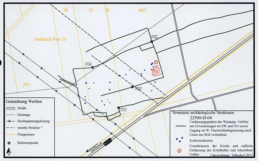
A deserted settlement is an abandoned settlement that is still commemorated by field names or documents and is still preserved in ruinous parts underground or even above ground. Such a deserted village was recognized in 2008 during an aerial flight in the area of today's municipality of Werben near Delitzsch. However, it was first photographed in 1994. The village area shows around thirty dark patches originating from pit houses or settlement pits, some of which lie in a line. They are enclosed by two large districts that partially overlap. This was probably a village ditch. Pottery found on the surface dates the village desolation to the 12th century. up to 15. Century. Written sources suggest that it was a village mentioned in documents as Naundorf or. Dümendorf, which fell into desolation in 1378. The well-known church site of Görlitz (Gerolticz), which was still in use until the end of the 14th century, could also be considered. Existence at the beginning of the century.
Ronald Heynowski/Annemarie ReckTrench structures
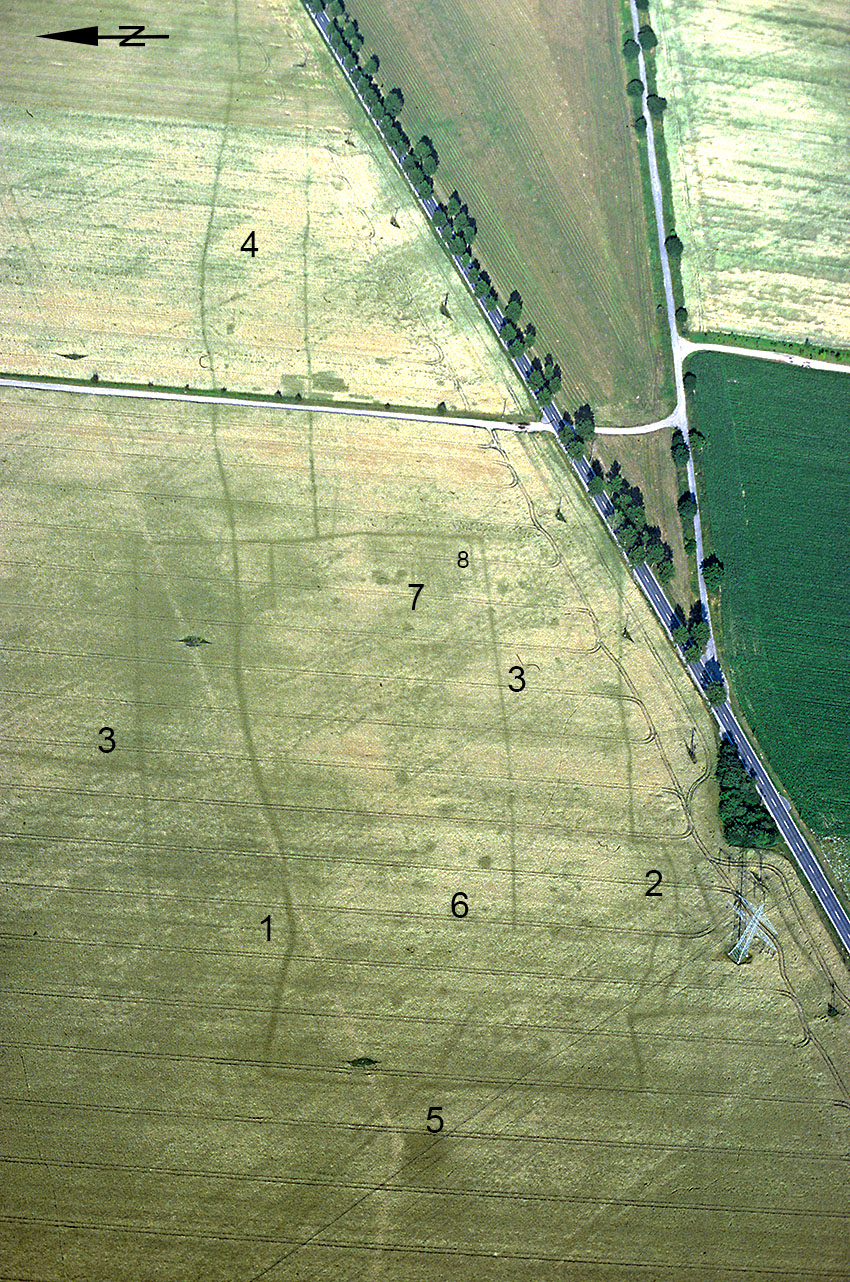
The village ditch appears as a linear rectangular structure in the field and overlaps several other, possibly not contemporaneous ditches. A section that bends to the southeast in the western third of the north side (1), but then continues eastward in an arc, is particularly easy to recognize. A bulge in the enclosure ditch (2) can be observed at about the same height on the southern ditch. A second, strictly rectangular ditch structure runs slightly offset to the north (3) and shares a common eastern side with the first structure.
Ronald Heynowski/Annemarie ReckImage Source O. Braasch, Foto ©LfA 1996.
Torgasse and annex
In extension to the main axis, further parallel ditches run about 500 m to the east (Fig. 1.4) before they are terminated by three transverse ditches. They lie exactly on the border of two fields. The field strips of the village were probably located in the area of this eastern annex. A gate-like interruption in the village ditch can be seen to the west (Fig. 1.5). The ditches form a narrow lane there, which runs north-west towards the village of Brenndorf over a length of 150 m that has been preserved.
Ronald Heynowski/Annemarie ReckImage Source OA 22500/27, Plan ©LfA 2008.
Church with a cemetery?
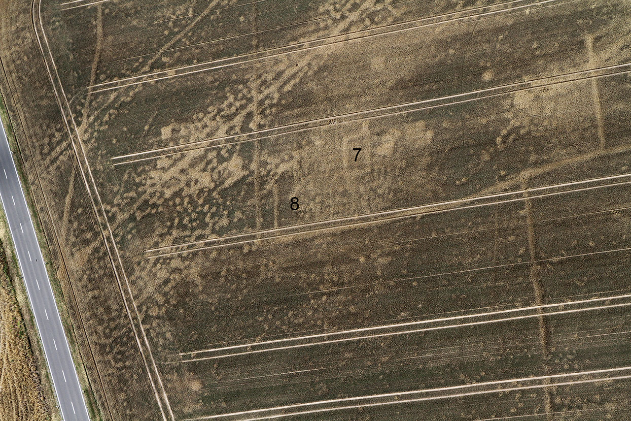
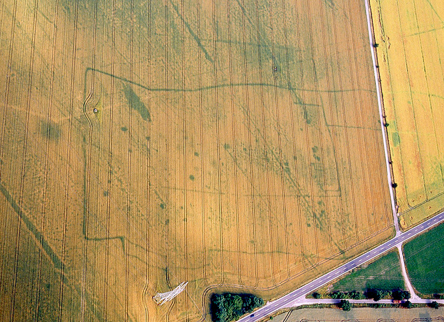
Within the village area, 30 discolorations are visible that indicate pits or pit houses (Fig. 1.6). Their location does not appear arbitrary. On the other hand, they occur in a fairly orderly fashion within a strip along the longitudinal axis and in the area of the eastern side of the village. A small rectangular structure in the far east (7) stands out in particular. It measures 7.5 x 14 m and has an east-west orientation. The visible positive traces of grain growth probably originate from the excavation pit of a stone foundation. Its size and orientation point to the village church. Under favorable aerial photography conditions, about 100 pits arranged in dense rows and aligned east-west can be observed to the south and east of this structure. This is probably the village cemetery (8).
Ronald Heynowski/Annemarie ReckImage Source R. Heynowski, Foto ©LfA 2015.
Reading finds
The finds collected during inspections of the field surface date from the 11th to 15th centuries. They are mainly blue-grey goods. Fragments of roof tile and mortar were also found in the area of the presumed church, which supports the assumption that it was built within the village. In addition, the finds of two flint tools indicate that the area was already used in prehistoric times.
Ronald Heynowski/Annemarie ReckImage Source R. Heynowski, Foto ©LfA 2008.
Görlitz or Naundorf?
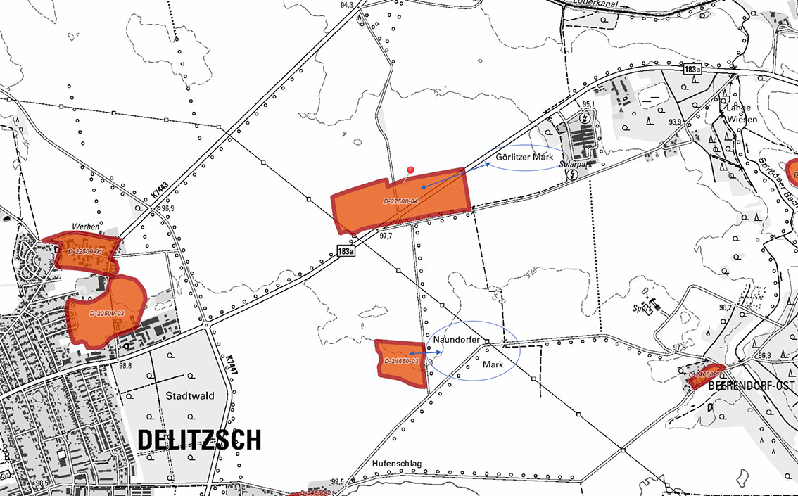
Two villages in this area are known from written sources to have been deserted during this period. Due to its location, it can be assumed that this was the village of Dümendorf (also known as Naundorf), which is said to have been located north-east of Werben. However, it is said to have been deserted as early as 1378. It is also not known whether the village had a church. It is also possible that it was the deserted village of Görlitz, which existed until the 15th century and is confirmed as the location of a church, which was by no means a matter of course for small villages in the High and Late Middle Ages. According to some sources, however, Görlitz is more likely to have been located near Laue. This is contradicted by field names that are still common today: the site borders closely on the "Görlitzer Mark", which is still common today, while the "Naundorfer Mark" lies around 900 m to the south, also close to a site with traces of a settlement.
Ronald Heynowski/Annemarie ReckImage Source A. Reck, Plan DIA/GIS ©LfA/GeoSN 2024.
Literature
Ronald Heynowski, Werben – eine Wüstung. In: Regina Smolnik/Ronny Zienert (Hrsg.), Höhenflüge. Luftbilder und Archäologie in Sachsen (Dresden 2024) 84–85.
Gustav Reischel, Wüstungskunde der Kreise Bitterfeld und Delitzsch. Geschichtsquellen Provinz Sachsen u. Freistaat Anhalt 2 (Magdeburg 1926) 155–158.
Note on monument protection
Archaeological monuments are protected by the Saxon Monument Protection Act. A permit under monument law is required for ground interventions or construction measures.
Permalink
https://archaeo-sn.de/en/ort/a-deserted-site-near-werben/
Citation
Ronald Heynowski/Annemarie Reck, A deserted site near Werben. In: Landesamt für Archäologie Sachsen, Website archaeo | SN (08.08.2024). https://archaeo-sn.de/en/ort/a-deserted-site-near-werben/ (Stand: 29.09.2026)
