

A village from the Imperial era near Leisnig
| Place: | Leisnig (Leisnig, Central Saxony) |
|---|---|
| Type: | Housing development |
| Dating: | Roman Empire | 200–375 AD |
Description
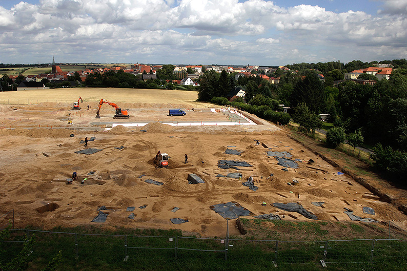
Due to the planned construction of a shopping center along the bypass road in the industrial park west of Leisnig, an area of 8,000 square meters had to undergo an archaeological survey beginning in late May 2015. During its initial survey of the site, the team from the State Office for Archaeology (LfA) of Saxony came across a pit house. After the topsoil was removed, numerous other features became visible in the ochre-colored loess loam, such as settlement pits, post holes, and hearths. Stone Age pit features and isolated Iron Age finds indicate that the site was visited on several occasions as far back as prehistoric times. In addition, finds collected from the field surface and scattered finds from earlier excavations indicate that the hilltop was used primarily for agricultural purposes from the 13th. into the 20s. century. Most of the findings could be dated based on the artifacts from the late Roman Imperial period (200–375 AD. Chr.) assign. Since no settlements from this chronological period had previously been known in the Leisnig area, this excavation filled a gap in our understanding.
Susanne Schöne/Gunar Seifert/Michael Strobel/Annemarie ReckTopographical and Cultural Context
The Middle Saxon loess hill country north of the Freiberger Mulde is one of the areas within the Free State of Saxony that has been regularly inhabited by farming communities since the early Neolithic period, approximately 5,500 years ago. Just a few kilometers further south of the deeply incised river valley, where the gently undulating terrain gradually gives way to the foothills of the Ore Mountains, the ancient settlement landscape comes to an end and the number of archaeological sites drops sharply. Settlement groups from the Roman Imperial period preferred gentle elevations with silty soils. Their settlements were generally located no more than 1,000 meters from a body of water. The Freiberger Mulde and the Schanzenbach are located 1,800 m and 1,400 m from the site to the north and south, respectively; however, the plateau was additionally drained by small streams. The town of Leisnig was founded under the protection of the former Lisnich castle settlement (later Mildenstein Castle) only during the high Middle Ages as part of the process of land acquisition. Historical maps indicate that the plateau in the area of the site has been used for agriculture since at least the 16th century and remained unwooded and undeveloped until the early 20th century.
Susanne Schöne/Gunar Seifert/Michael Strobel/Annemarie ReckImage Source K. Schneider, Foto ©LfA 2015.
The Houses
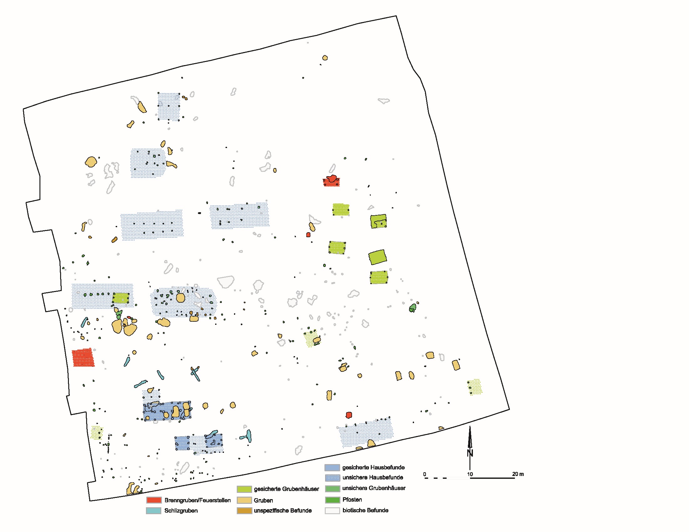
Although the distribution of finds across the excavation site appeared haphazard at first glance, a closer look quickly revealed very regular house floor plans, most of which were oriented east-west. These were two-aisled post-built structures measuring an average of 3.5 x 10.5 m. Compared to other known Imperial-era settlements in “Free Germania,” they are therefore quite small. Furthermore, the absence of hearths and a discernible interior layout suggests that these were not the mixed-use dwellings or farmsteads—consisting of a main building and an outbuilding with a pit house—that were more common at the time. The main buildings often featured multiple naves, as livestock was frequently housed in one section of the building during this period. Circular and elongated oval pits in the immediate vicinity of the building were likely used for storing provisions. Further unspecified post positions suggest the existence of other structures, though their dimensions and construction can no longer be determined.
Susanne Schöne/Gunar Seifert/Michael Strobel/Annemarie ReckImage Source Grabungsplan, Archæo 12/2015, 27, Abb. 2.
Mine Houses
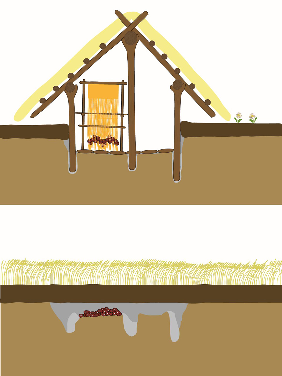
A short distance down the slope, at least four pit houses were identified. They have a typical, short rectangular floor plan measuring approximately 2.5 x 3 m and are also oriented east-west. With an average floor area of 9 square meters, the Leisnig pit houses are among the smaller examples of this building type. The structures, which were sunk several decimeters into the ground, had three post holes on each of their narrow sides. Similar post positions could indicate the presence of additional pit-house sites that may no longer be recognizable as such due to the slope of the terrain.
Susanne Schöne/Gunar Seifert/Michael Strobel/Annemarie ReckImage Source Rekonstruktion eines Grubenhauses, Archæo 12/2015, 28, Abb. 5.
Textile crafts?
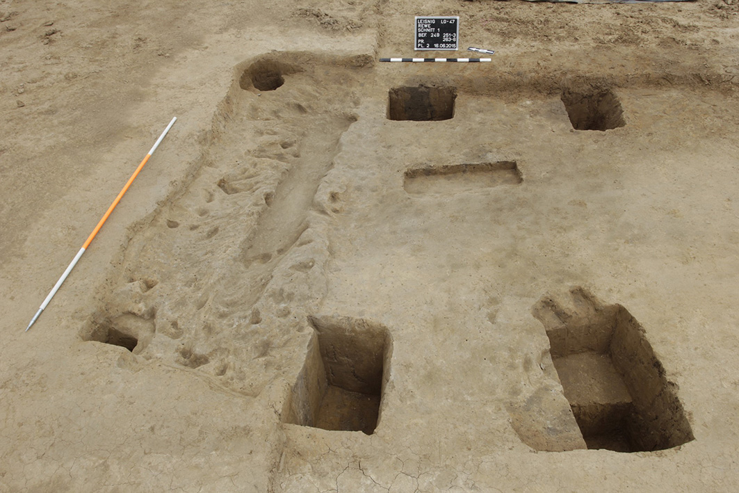
In two cases, the buildings could be identified only by the six post holes, which were buried to a depth of up to 70 cm; in two other cases, the interior negative impressions—preserved to a depth of up to 20 cm—were still intact and could be excavated accordingly. In one of the buildings, a long, oval-shaped pit caught the eye; it had likely been dug for weaving weights that hung from the warp threads. A loom was likely located at this spot. Unfortunately, apart from two spindle whorls found in the pit house fill, no clear evidence—such as the imprints of a loom frame—was found. Nevertheless, the findings seem to support the hypothesis that pit houses were frequently used for textile crafts. Scattered across the excavation area are also several settlement pits and hearths.
Susanne Schöne/Gunar Seifert/Michael Strobel/Annemarie ReckImage Source S. Schöne, Befundfoto ©LfA 2015.
Metalworking
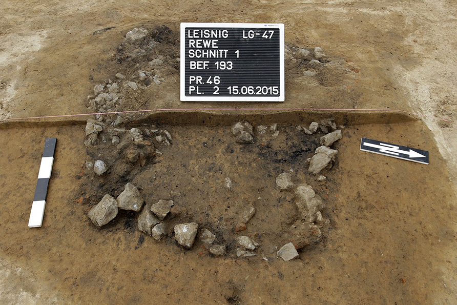
Evidence of on-site metalworking has also been found at the Leisnig settlement. For example, slag has been found on multiple occasions in the vicinity of the mining huts, as well as what are believed to be roughly rectangular “roasting pits” measuring 0.8 x 1 m. These structures, filled with stones, show signs of exposure to intense heat and are interspersed with charcoal residues and chunks of red clay. They may have been used for the thermal pretreatment of bog iron ore, which was subsequently smelted in bloomery furnaces. Similar findings are known from other Imperial-era farmsteads and workshops, such as Leuben (Nordsachsen district), Niegeroda, and Ebersbach (both in the Meißen district). In Leisnig, however, it appears that only the preliminary stage of iron production was uncovered in the excavation area. The smelting furnaces may have been located in another part of the settlement that was not affected by the planned construction. This is because while the findings become increasingly sparse toward the north, east, and southeast, the settlement appears to continue further to the southwest. The bog iron ore deposits, which the inhabitants used as a raw material, were likely located in the wet floodplains near the watercourses.
Susanne Schöne/Gunar Seifert/Michael Strobel/Annemarie ReckImage Source S. Schöne, Foto Befund „Röstgrube“ ©LfA 2015.
Ceramics and Dating
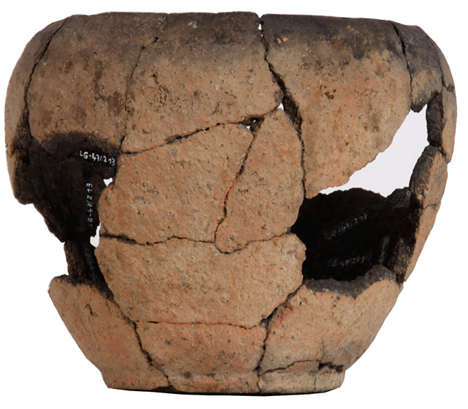
The ceramic finds consist of hand-built, coarsely tempered, and mostly undecorated fragments of unstructured pots and bowls. Only a few pieces feature decorations such as comb marks, diagonal grooves, horizontal grooves, and rows of finger dots or knobs running around the base. In addition, gray to gray-black ceramic fragments of bowls, made on a potter’s wheel, were found; these can be dated to Phases C2 and C3 of the Roman Imperial period in the Elbe Germanic region. In addition, the excavation finds include a total of three spindle whorls, as well as smoothing and grinding stones. Strikingly, however, there was a complete absence of metal and glass objects, which distinguishes the Leisnig site from other contemporary settlements. Apparently, everything of material or practical value was taken with the inhabitants when the settlement was abandoned. Several pieces of evidence suggest that the village on the plateau of present-day Leisnig was inhabited for only a few decades before it was finally cleared and abandoned.
Susanne Schöne/Gunar Seifert/Michael Strobel/Annemarie ReckImage Source Topf (Höhe ca. 19 cm), Archæo 12/2015, 29, Abb. 7.
Literature
Susanne Schöne/Gunar Seifert/Michael Strobel, Eine bislang unbekannte Siedlung der jüngeren bis spätrömischen Kaiserzeit bei Leisnig. Archaeo 12, 2015, 26–29.
Susanne Schöne/Gunar Seifert/Michael Strobel, Eine bislang unbekannte Siedlung der jüngeren bis spätrömischen Kaiserzeit (200–375 n. Chr.) bei Leisnig (Lkr. Mittelsachsen). Neuer Mildensteiner Erzähler 4, 2015, 2–3.
Note on monument protection
Archaeological monuments are protected by the Saxon Monument Protection Act. A permit under monument law is required for ground interventions or construction measures.
Permalink
https://archaeo-sn.de/en/ort/kaiserzeitliches-dorf-bei-leisnig/
Citation
Susanne Schöne/Gunar Seifert/Michael Strobel/Annemarie Reck, A village from the Imperial era near Leisnig. In: Landesamt für Archäologie Sachsen, Website archaeo | SN (03.12.2024). https://archaeo-sn.de/en/ort/kaiserzeitliches-dorf-bei-leisnig/ (Stand: 29.09.2026)
